Angel Falls Facts: Height, History, and How the Waterfall Formed
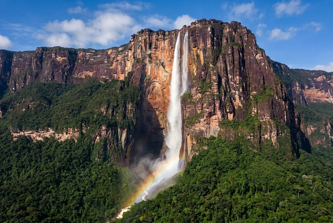
Angel Falls is the kind of place that generates questions faster than answers. How tall is it exactly? Why is it there at all? Who was Angel, and did the falls really form on a mountain older than most life on Earth? This guide gathers the essential facts about the world's highest waterfall, from its dizzying measurements to its geology, its indigenous name, and the aviator whose name it carries, and separates what is well established from the myths that have grown around it. Whether you are planning a trip or simply curious, these are the facts worth knowing.
How Tall Angel Falls Really Is
Angel Falls stands 979 meters, about 3,212 feet, making it the tallest uninterrupted waterfall on Earth. That single measurement is what draws people from across the world, and it is worth pausing on. The water falls the height of nearly three Eiffel Towers stacked on top of one another.
The total is made up of a main plunge of roughly 807 meters, the longest single drop, followed by a lower stretch of cascades and runoff that brings the full height to 979 meters. The main free-fall is so tall that the water often disperses into mist long before it reaches the base, especially in the drier months and on windy days.
This extreme height is the falls' defining fact and the reason the ground-level view is so hard to comprehend. Standing at the base, you crane your neck at a column of water pouring from a cliff so high that the top can vanish into cloud. It is a scale that photographs struggle to convey.
Why the Height Is Hard to Grasp
Because Angel Falls is a thin ribbon falling from an immense cliff rather than a wide, powerful curtain, its height can be deceptive in photos. The surrounding jungle and the sheer wall of Auyan-tepui provide the only scale, and even then the mind resists the true figure. Seeing it in person, with the top lost in mist, is the only way to feel the full 979 meters.
The Mountain It Falls From
Angel Falls does not pour from a peak but from the edge of a flat-topped mountain called Auyan-tepui. Tepuis are the table mountains of the Guiana Highlands, sheer-sided sandstone plateaus that rise abruptly from the surrounding jungle and savanna, and Auyan-tepui is the largest of them, with a summit area of roughly 700 square kilometers.
The falls spill from the western edge of this vast plateau, fed by rain that collects on the summit. That is why Auyan-tepui and Angel Falls are inseparable: the mountain is both the source of the water and the cliff that gives the falls their extraordinary height.
The name Auyan-tepui is often translated from the Pemon as Devil's Mountain, a reflection of the awe and unease the immense, cloud-wreathed massif inspired. To understand Angel Falls, you have to understand the mountain, an ancient island of rock rising above the forest, holding its own weather and its own world on top.
What a Tepui Is
Tepui means house of the gods in the Pemon language, and the name fits. These flat-topped mountains are remnants of an ancient sandstone plateau, their summits isolated for so long that they host unique plants and creatures found nowhere else. Auyan-tepui is one of more than a hundred tepuis scattered across Canaima National Park, the largest and most famous of them all.
How the Falls and Tepuis Formed
The geology behind Angel Falls is staggering in its timescale. The tepuis are the eroded remnants of a vast sandstone plateau laid down as part of the Roraima Formation, rock that dates back on the order of a billion years and more, among the oldest exposed rock on the planet.
Over immense spans of time, erosion carved away the softer surrounding material and cut this ancient plateau into the isolated table mountains we see today, their sheer cliffs marking where the rock resisted. Angel Falls exists because water gathering on the summit of Auyan-tepui simply pours off one of these towering edges.
This deep history is part of what makes the place feel otherworldly. You are looking at a waterfall falling from the flank of one of the oldest landscapes on Earth, a surviving fragment of a world that predates the forests around it by an unimaginable margin. The scenery is not just beautiful; it is a window into the planet's deep past.
An Ancient Landscape
The antiquity of the tepuis captured imaginations long before tourism, inspiring the idea of isolated highlands where the ancient past survives. While the fiction exaggerated, the underlying truth is real: these are among the oldest and most isolated landforms on Earth, and their summits do harbor species found nowhere else. Angel Falls is the dramatic edge of that ancient world.
The Pemon Name and Indigenous Knowledge
Long before any outsider saw Angel Falls, the Pemon people knew it well. Their name for the falls is often given as Kerepakupai Vena, sometimes rendered Kerepakupai Meru, understood to mean something like the waterfall of the deepest place. The falls and the mountain were part of Pemon geography, story, and spiritual landscape for generations.
This matters because the modern name can obscure a much older relationship. The Pemon are the indigenous people of this region and remain its stewards; the licensed guides who lead visitors to the falls are Pemon, and the land sits within their ancestral territory.
Knowing the indigenous name and history is part of visiting respectfully. Angel Falls did not appear on the world's radar in the twentieth century; it appeared on Western maps then. To the Pemon, Kerepakupai Vena was always there, and honoring that longer story is part of understanding the place fully.
Jimmie Angel and the Name
The falls take their English name from Jimmie Angel, an American aviator, sometimes written Jimmy Angel, who brought them to the wider world's attention in the twentieth century. He first flew over the falls in the early 1930s while searching the region by air, and in 1937 he returned and attempted to land his small plane on the summit of Auyan-tepui.
The landing went wrong: the aircraft became stuck in the boggy ground on top of the tepui, and Angel and his companions had to make a difficult descent on foot over several days to reach help. The story captured imaginations, and the falls came to bear his name, appearing as Angel Falls on maps issued in the years that followed.
It is worth holding both truths at once. Jimmie Angel is genuinely part of the falls' modern history and the reason for their global name, and the Pemon knew and named these falls long before him. The full story includes both the aviator's dramatic tale and the far older indigenous relationship with the place.
Fact Versus Legend
Many colorful claims swirl around the Jimmie Angel story, and not all are equally well documented. The core facts, that he flew over the falls in the 1930s, attempted a summit landing in 1937 that stranded his plane, and gave the falls their English name, are well established. Treat more elaborate details with a little caution, as legend has embroidered the record over the decades.
Seeing the Facts for Yourself
Reading the figures is one thing; standing beneath 979 meters of falling water is another. Angel Falls sits deep in Canaima National Park, a UNESCO World Heritage Site since 1994, roughly the size of Belgium and studded with more than a hundred tepuis. There are no roads; visitors fly to Canaima village and travel by motorized canoe up the rivers to reach the base.
The classic trip is a multi-day expedition in the rainy season, when the falls run full and the boat can reach them, while the dry season offers clearer skies and scenic flights over the falls from the air. Either way, seeing the falls in person turns the facts into something felt rather than merely known.
The numbers and history are the frame; the experience fills it. Knowing the height, the geology, the Pemon name, and the Jimmie Angel story makes the trip richer, because you arrive understanding what you are looking at: the tallest waterfall on Earth, pouring from one of its oldest landscapes, in the heart of indigenous Pemon country.
A Few Numbers to Remember
Carry these with you: 979 meters or about 3,212 feet total height, a main drop near 807 meters, a summit source on Auyan-tepui of roughly 700 square kilometers, over 100 tepuis in Canaima National Park, and UNESCO World Heritage status since 1994. These are the facts that turn a beautiful view into a comprehensible wonder when you finally stand before the falls.